January looks to be slightly below normal in temperatures with above normal snowfall. Look out for those lake effect snow events especially early in the month. Average high temperatures are 32 degrees and the low is 16 degrees. My monthly mean high temperature forecast is 29 degrees or -3 Degrees from the normal. My monthly mean low temperature forecast is 17 degrees or +1 degree from the normal.
January Summary…
It will start off mild in the first few days of January and then a big cool down with snowy and even some lake effect snows. Colder by end of the month.
February looks to be much colder than normal with near normal snow fall. Watch out for strong storm system and even a few arctic blasts following the clippers. My forecast hi temperature is 25 degrees or -9 degrees from the normal. My forecast monthly average low is 16 or -1 degree from the normal.
March looks to be very cold. My forecast daily monthly means temperature is -10 degrees from the normal of 33. Watch out for a prolonged winter in the Northeast.
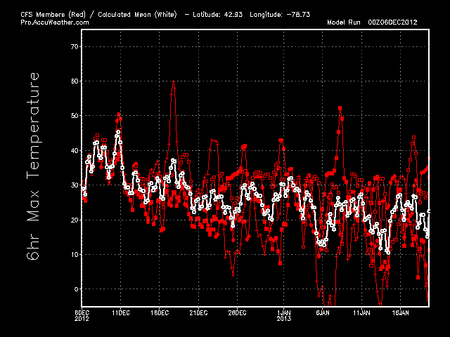
Here is the Major CFS
Models for WNY… Buffalo Local Maps


National Model Maps
January 2013

500 MB Heights Notice the trough in the Great Lakes Region
and the Ridge in the West. This indicated a +PNA and a somewhat –NAO and even a
–AO

500 Height Anomaly Look at the red near the Western
Greenland. This is the blocking pattern that may set up a stormy one for the
Northeast and East Coast. Cold air will filter in underneath this positive
height anomalies and bring colder air for the Eastern US.

This is the foretasted departures of the 850 MB Temps for
January. Notice the warmth in the East I feel this is over done and will need
to be taken down. In the Northeast and Great Lakes Region may see below normal
temperatures based on the previous maps.

This is the 70 MB Relative Humidity Forecast Anomalies. It
seems to be drier than average due to the cold weather.
February 2013

Look at the trough in the East and a ridge just off the East
Coast and in the Gulf of Alaska and Northwest.
This tells me that the PNA will be Positive and the NAO will be strongly
negative. In a nut shell cold in the East; Warm in the West except in the
Southwest where a bit of split flows will take shape.

It even shows up here on the temperature anomalies at the
850 MB Level. I expect a bit colder than normal in the North East Too. Warmer
than what is being said in the Northwest.


Even the 700 MB RH is showing wetter than normal in the East
and West.
March 2013

Big trough in the Eastern and Mid-West Regions. A Big Ridge
in the West. This shows me that much colder air for the East.

It is even showing here on the 850 MB Temperatures
Anomalies. I have a hunch that the Northeast and Mid-West will be colder than
normal during this time. Stay Tuned.
CPC Forecasts


No comments:
Post a Comment